

Explored with Bryag and Zimbob – North Sutor on the Saturday, and South Sutor on the Sunday. We got cracking summer weather – but these places are truly grim in winter.
South Sutor CASL's – very inaccessible
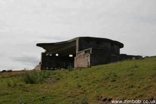
One of the bunkers at South Sutor
Minefield galvanometer bunker at South Sutor
Alongside Rosyth and Scapa Flow, Invergordon was one of the Admiralty’s major naval bases in the Great War, and was also heavily used during the Hitler War. Built a few miles from Invergordon, these sets of artillery batteries, collectively known as The Sutors, are among the best-preserved installations of their type in Scotland. They sit on cliff headlands over 450 feet high, guarding both sides of the Cromarty Firth where it leads from the North Sea into the former Naval base at Invergordon. By contrast, the batteries that protected Rosyth sat on birdcrap-coated islands in the Forth, and have been utterly stripped of anything interesting.
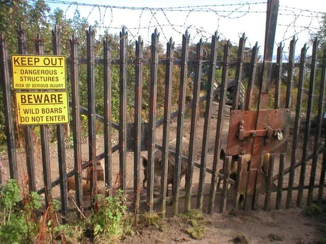
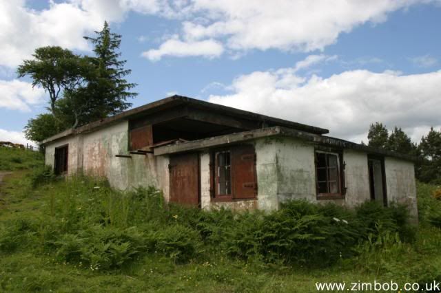
North and South Sutor are so-called because they resemble two old soutars hunched over their work: soutar is the Scots for cobbler, as in Soutar Johnnie in Burns' masterpiece, Tam o' Shanter. The best-preserved parts are at Fort South Sutor, the former 244 Coastal Battery, where gun emplacements, magazines, rangefinders and the remains of other equipment, such as the anti-submarine minefield, sit inside an “unclimbable fence” (that’s what it says on the Ministry of War plan). Also inside the fence are wild boar, with the result that we think we’re the first to brave the boar and explore what lies inside the fence. At least since the boar were installed. Bryag went first, speculatively, and we looked on with interest to see whether he would be gored. Once he reached the safety of an emplacement roof, I clambered over … then shortly afterwards, Zimbob followed after having been goaded by Bryag into joining us.
Plinths for rangefinders, South Sutor
Board-marked concrete, South Sutor
Emplacement No.1, South Sutor
The Guns
The port of Invergordon became a naval base in 1913, and The Sutors were similarly built before the outbreak of World War I, anti-shipping forts comprising a comprehensive set of defences – not only the anti-ship artillery batteries, but by WW2 a minefield and boom defence, searchlight batteries, lookouts and observation posts, which were eventually stood down in the Fifties. After parking up at South Sutor, we visited the Fire Command Post first, at the top of the hill, with the Mine Watching Station and a couple of small bunkers near where a generator was marked on the War Department’s plan of the fort (it powered the minefield, see later). At various times during WW2, both North and South Sutor were manned by the Norwegians – http://home.online.no/%7Egestrom/history/cstalfrm.htm
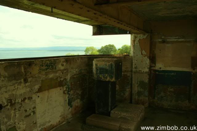
Downhill are the WW2 emplacements – each armed with two 6-inch MkVII guns on CPII mountings, which were installed in November 1939. The magazine of the No.1 Gun is flooded to within two feet of its ceiling – but further along, the No.2 Gun emplacment is of a virtually identical design, and you can climb down the magazine escape shaft to access it. A steel tube has been used as an internal lining to cast the concrete against, and it drops around 20 feet. Both magazines retain their shell slides, and cranes, and you can see the remains of the timber linings against which the brass shells were stored. There was less sign of ammunition elevators, but as is traditional when I visit places like this, I accidentally dunked a foot in what I thought was a flooded cable pit but which I think now might have been the elevator pit? I wasn’t the only one – http://www.corestore.org/guns.htm
Emplacement No.1, South Sutor
Zimbob investigates the No.1 magazine escape shaft, South Sutor
No.2 magazine escape shaft, South Sutor
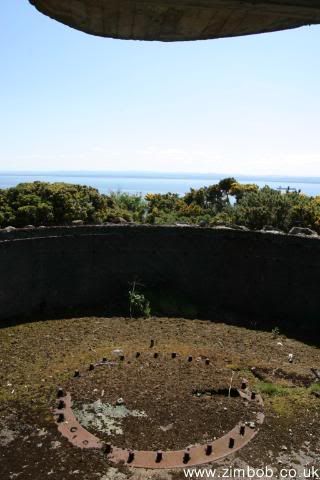
The WW1 guns, of 12 inch calibre, sat in massive concrete emplacements, with a glacis at the front (to deflect incoming shells), a circular well, and a central keyhole-shaped inner well. One emplacement still has a steel rail to prevent the gun barrel elevation dropping too low and firing into the ground. In WW2, the former emplacements became magazines, which explains why the escape shafts emerge from the middle of the "keyhole". After the war, the batteries were placed on a care and maintenance basis in April 1945 and the guns were removed in 1956.
The Radars
Both Fort North Sutor and Fort South Sutor were equipped with centimetric band fire control radar sets in the early 1940's, so-called “splash-spotting" radars, very similar to the gun-laying radars fitted to WW2-era battleships, which were used to give accurate ranges and bearings to targets, and enable corrections to be made to their trajectory once drift had been taken into account. The radars were mounted on small concrete buildings, and no equipment is left inside to positively identify them.
No.2 magazine, South Sutor
North Sutor from South Sutor
South Sutor from North Sutor, above the WW1 emplacements.
The Mines
At the outbreak of World War II, the Royal Navy installed "controlled mines" and associated "guard loops" between the Sutors, to detect and destroy German U-Boats. In the late 1930’s, the Navy planned four mine loops and two guard loops and in late 1939 mine-laying began in earnest. The mine loops at Cromarty required 30 miles of cable with another 13 miles of cable was needed for the ”tails”. Having had a rake around on the net, I’ve spotted that the heavy cables which had been chopped off as they entered a bunker at South Sutor were connected to the submarine detectors in the channel, and the concrete “fire surrounds” nearby were (possibly) to hold the galvanometers associated with them. The sawn-off ends of the 1 1/8 inch cables are still visible – hefty undersea multi-core cables with copper cores wrapped in india rubber, a ring of steel armour cables, then hemp sheathing and a thick black coating of pitch and resin.
In 1945 the Royal Navy exploded the mines, as attempts to recover loops, sinkers and junction boxes tended to be unsuccessful due to a lack of power in the mine recovery winches. It’s not known how much of the mine loops were recovered from Cromarty, as individual records seem not to have been kept: it’s possible that there are still many miles of cable under the Cromarty Firth. Which leads neatly on to Zimbob’s pirate theory: a large container ship was sitting at anchor beyond the fairway buoy, flying the Jolly Roger (or so Zimbob claimed, though we couldn’t make out the flag clearly). We did wonder what the pirates were after, but the minefield cables would be a suitable target. Henceforth known as the water pikeys, they were lifting cables from 25 fathoms using a grappling iron and shouting Arrrrr Jim Lad … in Zimbob’s alternative universe.
North Sutor No.1 emplacement, with the pirate ship in the background.
North Sutor No.2 emplacement
No.2 magazine escape shaft, North Sutor
The Boom and The Searchlights
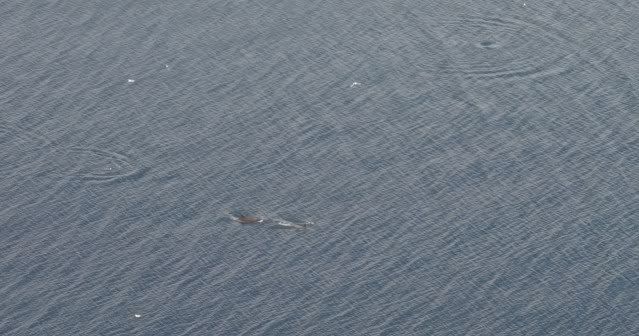
Nothing can be seen of the boom from the batteries, but there may be some remains closer to the water. The searchlight batteries themselves lie in ridiculously inaccessible locations and will require 400 feet of rope, a harness and an ascender in order to reach them safely – and more importantly, be able to return to civilisation again. North Sutor has many similarities to South Sutor – but no boars. In fact, a good weekend for livestock … a buzzard inside a shed; dolphins off the Sutors; crickets; the Lamb Gang, who try their best to look meek but run away guiltily when you come close to them; and those small white moths which rise up in clouds from the clover.
Vent cast by Carron Company, the world's first industrialised foundry
Surface bunker, North Sutor
Lookout tower, North Sutor
Results 1 to 10 of 11
-
23-06-2009, 09:30 PM #1wolfism Guest
 The Sutor Forts, Invergordon June 09
Last edited by wolfism; 23-06-2009 at 09:33 PM.
-
23-06-2009, 09:41 PM #2
 A Country Member
- Join Date
- Feb 2009
- Posts
- 186
- Thanks
- 173
- Thanked 14 Times in 11 Posts
Re: The Sutor Forts, Invergordon June 09
Nice find and cool photos. Looks to be a good explore.
...Hear me now from the Invisible Opera Company of Tibet...
Neolithicsea.co.uk
-
23-06-2009, 09:43 PM #3
UF Silver Member
- Join Date
- May 2008
- Posts
- 1,180
- Thanks
- 82
- Thanked 117 Times in 85 Posts
Re: The Sutor Forts, Invergordon June 09
That looks a great place to visit mate, really good. Nice history and the ladder shot is fab

-
24-06-2009, 03:54 PM #4wolfism Guest Re: The Sutor Forts, Invergordon June 09
Cheers all for your comments. Yep, we had Obelix with us, in the form of Bryag.

-
24-06-2009, 04:08 PM #5
Not Like Cordial!
- Join Date
- Apr 2008
- Location
- North of Leeds
- Posts
- 274
- Thanks
- 42
- Thanked 22 Times in 22 Posts
 Re: The Sutor Forts, Invergordon June 09
Really interesting stuff wolfism! Amazing whats just left after so long. The photo & the lighting within your second to last is good!
-
24-06-2009, 09:06 PM #6
UE Addict
- Join Date
- Jan 2009
- Location
- Norfolk
- Posts
- 394
- Thanks
- 51
- Thanked 84 Times in 82 Posts
Re: The Sutor Forts, Invergordon June 09
What a great report and history, looks an interesting visit, well done.
Seek find and grind!
http://www.flickr.com/photos/stiemer/
-
24-06-2009, 09:33 PM #7
UF Senior Member
- Join Date
- Nov 2008
- Location
- The icy wastes of rural Lincolnshire
- Posts
- 181
- Thanks
- 0
- Thanked 1 Time in 1 Post
Re: The Sutor Forts, Invergordon June 09
Another great report and photos. I love the one of emplacement no.1.
Boars are usually very shy but well done on the unclimbable fence
-
27-06-2009, 07:01 PM #8
Addicted to the Shindig..
- Join Date
- Nov 2008
- Location
- Inverness
- Posts
- 96
- Thanks
- 8
- Thanked 9 Times in 6 Posts
Re: The Sutor Forts, Invergordon June 09
Nice work Wolfism, some cracking shots too:
Meh, I'm not convinced Originally Posted by Muse

 I've tangled with Security, Pikeys, and hidden from the Rozzers, and none of 'em came close to the boars for getting the adrenaline going
  gay
gay
Some wildlife shots ...
Said boars :
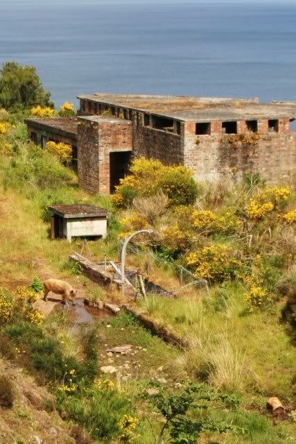
And from a previous visit :
Spotted dolphins whilst debating whether or not to enter the boars lair :
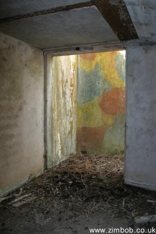
There was still 'Dazzle Paint' remaining in the WW1 QF emplacement
Fire Command post, shutters and some paint still there :
Rangefinder plinth, WW2 emplacements, South Sutor :
One of the magazines, South Sutor :

North Sutor WW" emplacement, for BIG gun
The sunlight streaming in the vents in some of the bunkers made for great lighting
Looking up to No2 emplacement :
Twas a good coupla, days, pirates, boars and great weather, everything you want
"I wasn't born of a whistle or milked from a thistle at twilight; no, I was all horns and thorns sprung out fully formed, knock-kneed and upright"
-
27-06-2009, 07:53 PM #9
UF Senior Member
- Join Date
- Nov 2008
- Location
- The icy wastes of rural Lincolnshire
- Posts
- 181
- Thanks
- 0
- Thanked 1 Time in 1 Post
Re: The Sutor Forts, Invergordon June 09
On second thoughts I wouldn't mess with them when they've got young! You are fearless
-
27-06-2009, 10:56 PM #10wolfism Guest Re: The Sutor Forts, Invergordon June 09
Nice one Zimbob – in all the excitement, I didn't get any boar photos at all … however, at least we didn't have to enact Lord of the Flies.


 Reply With Quote


